Processing territorial landscape studies

Navigační obrázek služeb v oblasti územního plánování a rozvoje
Spatial development and planning

In the context of Act on Spatial Planning and Building Rules, a territorial landscape study is a spatial planning background materials. It is a comprehensive document dealing with landscape throughout the administrative units of the municipality with extended power. Territorial landscape studies are supported by the Integrated Regional Operational Programme (IROP). The grant recipients are municipalities.

Guarantor: Mgr. Hana Trávníčková


Územní studie krajiny: problémový výkres


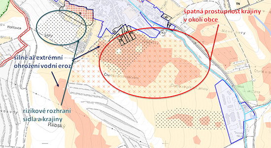
Territorial landscape studies  (ÚSK) are processed primarily for planning purposes. Unlike spatial plans, however, ÚSK provide considerably more detailed and comprehensive solutions for the land of interest that overlap municipalities. They provide municipalities with supportive material for new spatial plans or for their updating, and serve to update spatial analytical data for municipalities with extended power. ÚSK provide a whole range of material and outputs useful for

  • making spatial planning decisions (nature conservation, water authority, agricultural land protection, etc.),
  • preparing both complex and minor projects,
  • coordinating other activities in the area (e.g. comprehensive land consolidation).

Who is this service intended for

The beneficiary of ÚSK is the planning authority of municipalitites with extended power.

Service contents

We offer to process regional land studies as

  • important planning background materials usable for future development and for the racional use of landscape,
  • comprehensive document that deals with landscape throughout the whole area of municipalitites with extended power.

Experience

  • Pilot territorial landscape study for parts of ORP Kyjov, 2016

Related services

Navigační obrázek služeb v oblasti územního plánování a rozvoje

Processing and updating spatial analytical data

Spatial analytical data (ÚAP) are processed in accordance with Act no. 183/2006 Coll., on Spatial Planning and Building Rules (“Building Act”). The condition and development of the area is identified and evaluated. They also form one of the bases for planning documentation and making changes to it for acquiring planning studies and for making decisions concerning the land.

Navigační obrázek služeb v oblasti územního plánování a rozvoje

Processing comprehensive land consolidation

We organize, combine and divide up land into working and spatially consolidated units and ensure access to them. We help to improve the environment and to protect land resources, reduce the negative effects of flooding nad solve drainage conditions in the landscape, and increase the ecological stability of the landscape. The results of land consolidations serve for renewing cadastral documentation.

Ask for more information. Call 721 222 994

Or write your question here